
The Perfect 1-Week Utah & Arizona National Parks Road Trip — Map & Itinerary
We just got back from a whirlwind week-long road trip through the beautiful national parks in Utah and Arizona. These iconic landscapes are truly unique to the American west, and a national parks road trip has been on our bucket list for quite some time. We visited Canyonlands National Park, Arches National Park, Capitol Reef National Park, Bryce Canyon National Park, Horseshoe Bend, Lower Antelope Canyon, Monument Valley, and Canyon de Chelly — all in one week! Check out the guide below to learn more about these beautiful destinations and to see a helpful Utah and Arizonal national parks road trip map.
When we went: April 26th through May 4th. We aimed to visit when the weather had started to warm up and before schools were out for summer. We definitely experienced fewer crowds than if we had gone in summer, but make no mistake — the parks draw a heavy volume of visitors year-round. We had a few weather scares, but ended up totally lucking out! It only rained while we were sleeping or driving from place to place, and we got perfect weather every time we set out to hike and explore. It was warm (70s) in the Moab area (Arches and Canyonlands), in Capitol Reef, and in the Page, AZ area (Horseshoe Bend, Antelope Canyon, Monument Valley), mild (60s) in Canyon de Chelly, and a bit chillier (40s-50s) at higher elevation in Bryce Canyon.
What we listened to: Desert Daydream playlist here.
GETTING TO & AROUND THE UTAH & ARIZONA NATIONAL PARKS
Since we’re based in Denver, we were able to leave on a Friday afternoon and drive 5 hours straight to Moab. See the Utah and Arizona road trip map below for the route we made from Denver, CO >> Moab, UT (Arches and Canyonlands National Parks) >> Capitol Reef National Park, UT >> Bryce Canyon National Park, UT >> Page, AZ (Horseshoe Bend, Antelope Canyon) >> Monument Valley, AZ >> Canyon de Chelly, AZ >> Pagosa Springs, CO > Denver, CO.
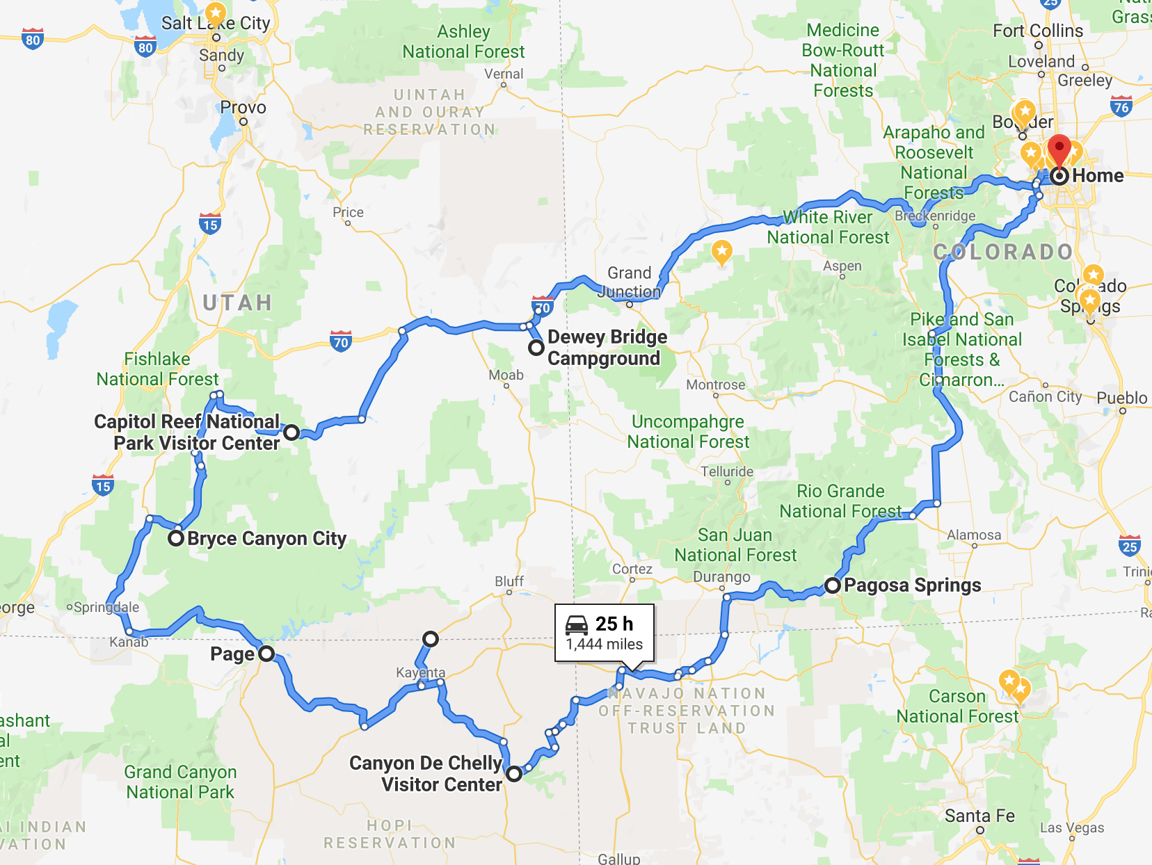
Utah and Arizona National Parks road trip map
If you’re planning on flying in, the popular hubs to access the Utah and Arizona national parks are Salt Lake City and Las Vegas. A more typical loop would include Zion National Park in Utah, and Grand Canyon National Park in Arizona. We couldn’t fit these stops into our week-long itinerary and opted for the more hidden gem Canyon de Chelly in Chinle, Arizona instead. We definitely want to come back and visit those two another time!
🔥Hot Tip: We received a National Parks Pass (thanks, Ray’s grandma!) before our trip and it’s a must if you’re visiting three or more national parks or recreation areas during a given year. Each park costs about $35 for daily entry, and for the price of $80, an annual pass will save you money by getting you into all of them for free — just show it along with your ID at the entrance!
DAY BY DAY UTAH & ARIZONA NATIONAL PARKS ITINERARY
Day 1: Denver, CO to Moab, UT
We left as early as we could considering we still worked on Friday, which ended up being around 3pm. Tbh, this trip was also planned a bit last-minute and we knew that only first-come first-served campsites would be available, so we were prepared to have to check a few campgrounds or even sleep in our trusty Subaru. This made us a little anxious as we rolled up to the first campsite on our list — Dewey Bridge Campground outside of Moab, UT — around 8pm just after the sun had set. Surprisingly, we were able to find an open campsite and set up our tent just before it began to rain. We were relegated to a cold meal in our tent since we didn’t want to venture out into the storm, but were happy to have a place to sleep for the night!
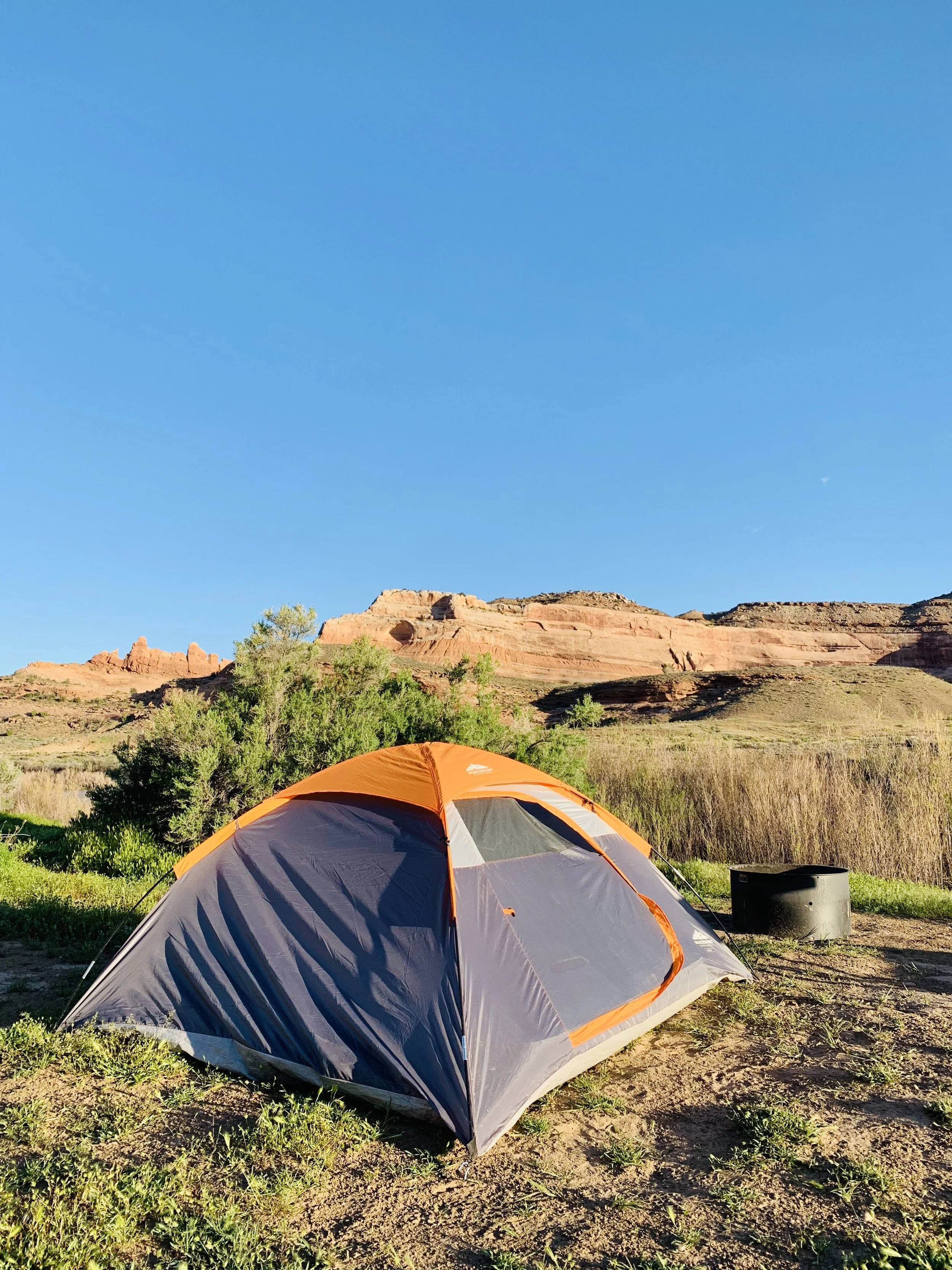
Our campsite at Dewey Bridge.
⚙️Gear Recommendations:
Our tent is a super simple 2-person tent — nothing fancy — which we actually love because it’s so quick to set up. Here’s a similar tent with great ratings for your National Parks trip and future camping adventures. Here are a few more of our recommendations for your camping essentials:
Because it’s never NOT cold while camping, we recommend a lightweight cold-weather sleeping bag like this one
Headlamps so you can keep the fun going (or find your way to the bathroom) when it gets dark
Lanterns (for the same reason)
Insect repellant — something we always forget and always wish we had
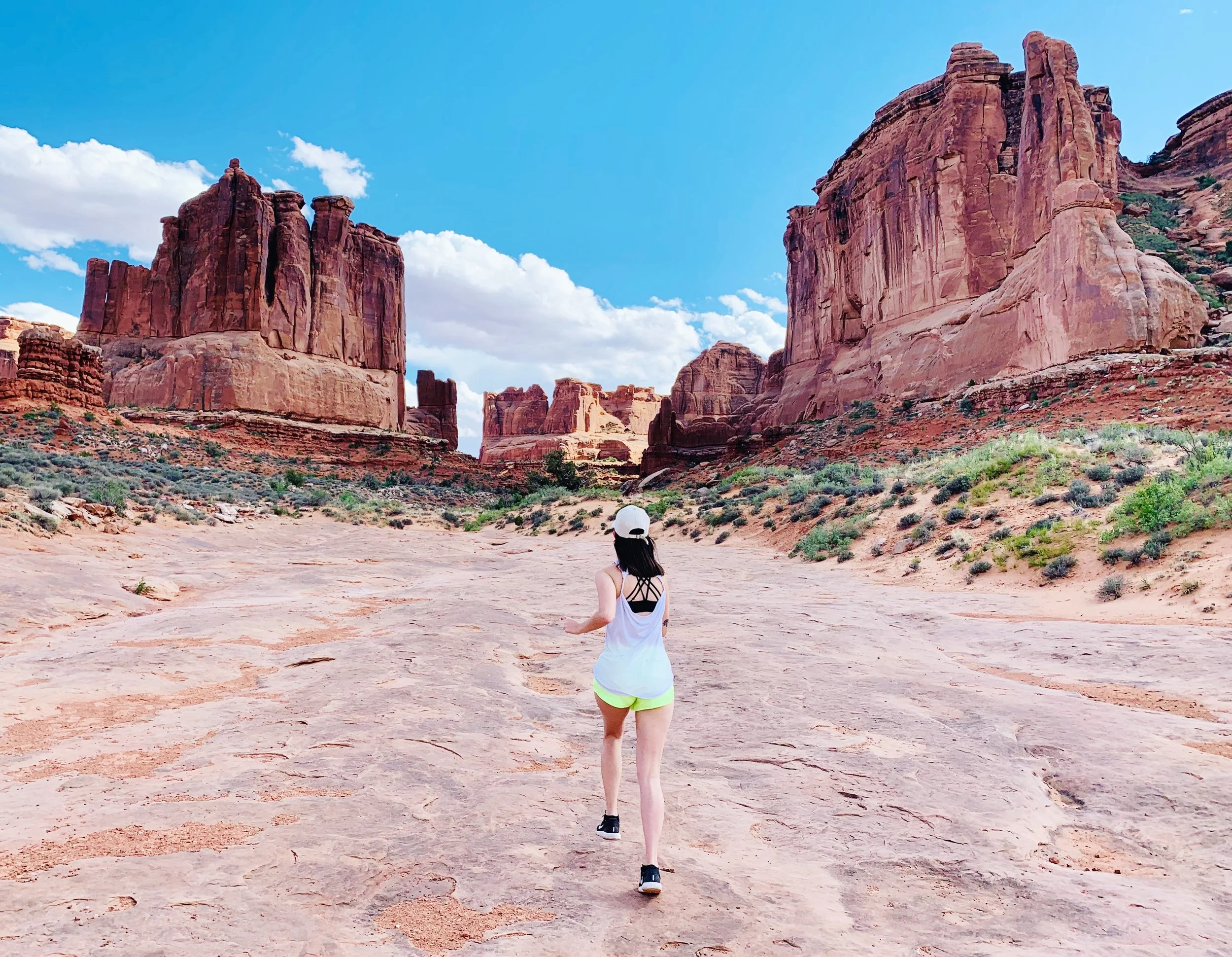
Day 2: Canyonlands and Arches National Parks (pt. 1)
We woke up bright and early (as is always the case when camping, right?) and finally got to see our surroundings by the light of day. We were situated right between a majestic mesa and the Colorado River, and everything looked so peaceful and beautiful in the morning light. After a quick breakfast, we set off to explore! Though Dewey Bridge is a bit outside of Moab, it was a beautiful drive through Castle Valley to get there. On first sight of the beautiful canyons and valleys dotted with buttes and rocky spires, we quickly became accustomed with the constant state of awe this part of the country would inspire for the rest of the trip.
Canyonlands National Park spans nearly 338K acres, and is made up of three sections: Island in the Sky, The Needles, and The Maze. These three sections are all separated by vast canyons (go figure) and thus are actually an hour plus drive away from each other, so you really need to prioritize which parts you want to hit.
Island in the Sky is the most popular stop for first-time visitors, as it features sights you can drive to for the most part, while The Needles requires hiking to see the major sights. The Maze is the least accessible region of Canyonlands, and can really only be experienced by backpacking excursions that span three or more days.
That said — we went to Island in the Sky first. We didn’t have any expectations going in, and were really surprised about how organized all of the parks are. We expected to have to choose a couple hikes which would lead to a couple popular sights, but for the most part, the major sights and overlooks at Island in the Sky are located a quick walk from the road that loops through the park. For that reason, we were able to hit almost every single one on the map in just a couple hours. Check out the photos below for our favorites!

Shafer Canyon Overlook, the first stop from the Visitors Center at Canyonlands Island in the Sky area and our favorite stop of the day!
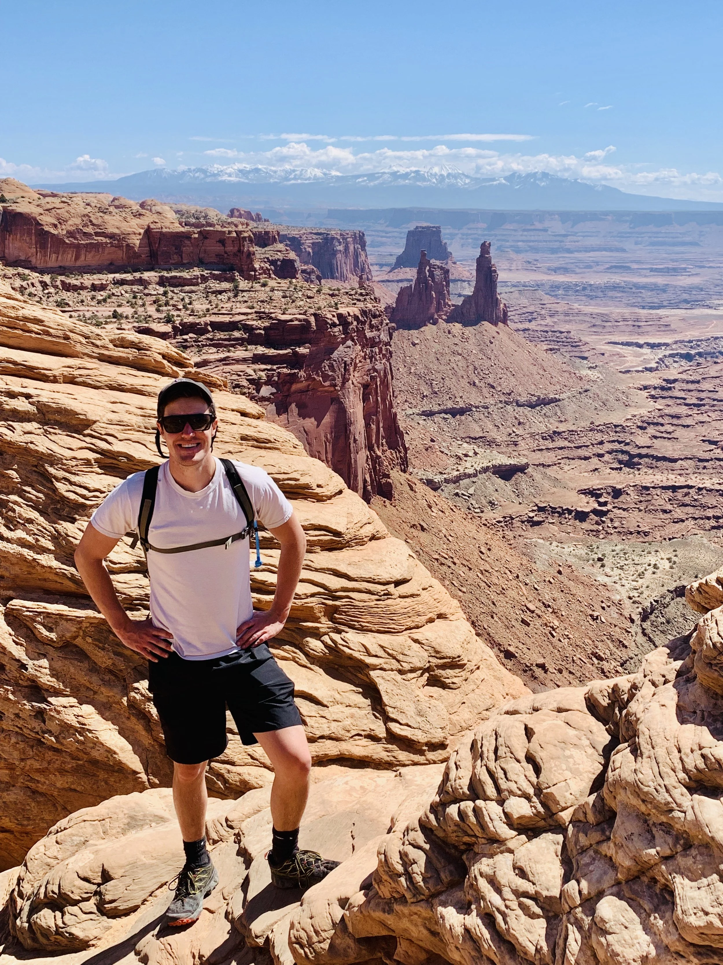
Ray near Mesa Arch, Canyonlands
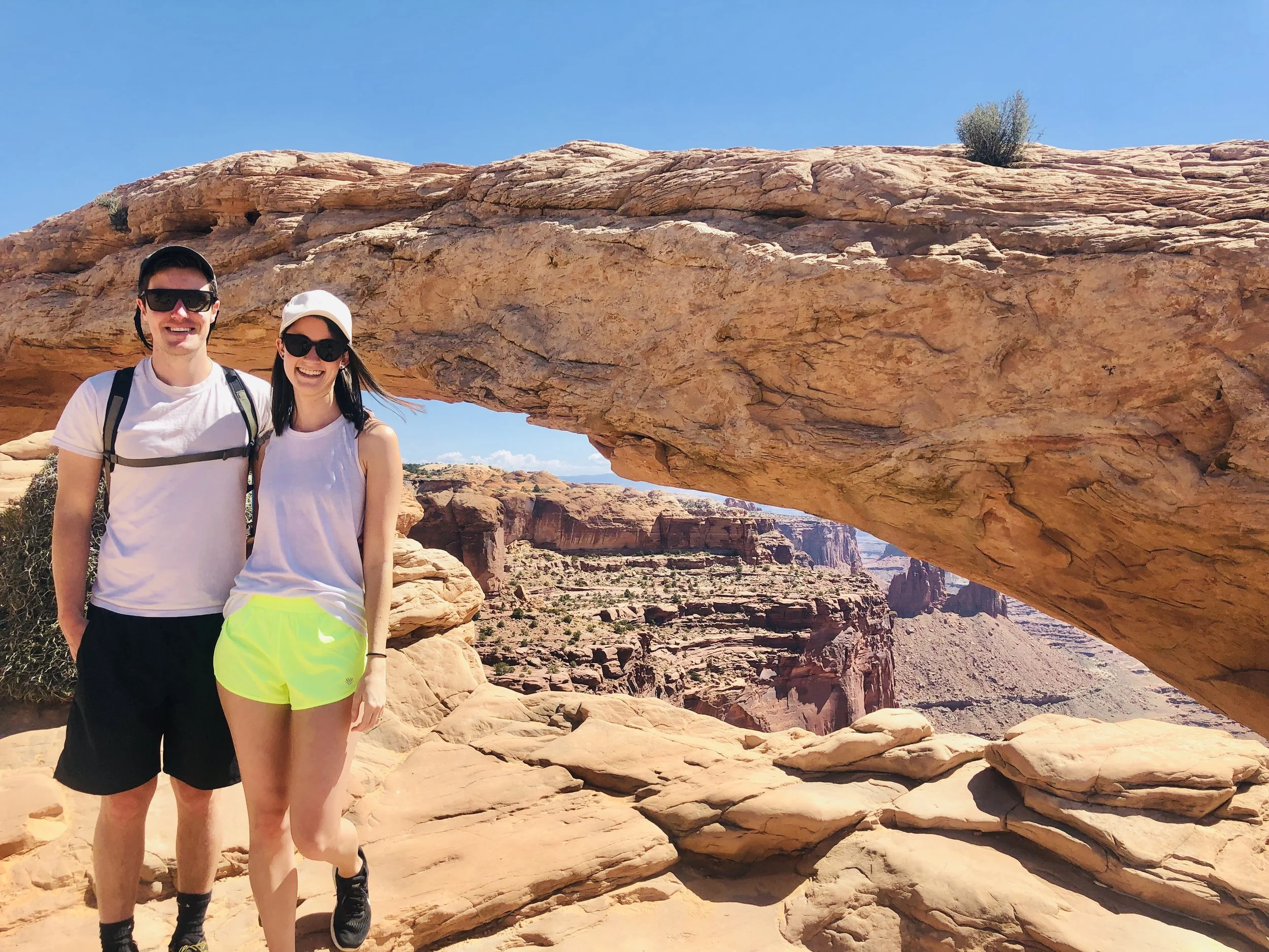
Mesa Arch, Canyonlands
⚙️Gear Recommendations:
With time left to spare, we made a quick stop back in Moab to load up on firewood and other camping necessities, and then decided to hit Arches National Park for the rest of the afternoon and early evening.
Again, while there are tons of hikes you can do, and some of the popular sights can only be accessed by hiking, a lot of them are right off the main road. We did the full drive through Arches that evening, stopping for photos all along the way, making plenty of #phallicsymbols jokes, and prioritizing which hikes we wanted to come back and do the next day.
Park Avenue, Arches
Day 3: Arches National Park (pt. deux) and Capitol Reef National Park (pt. uno)
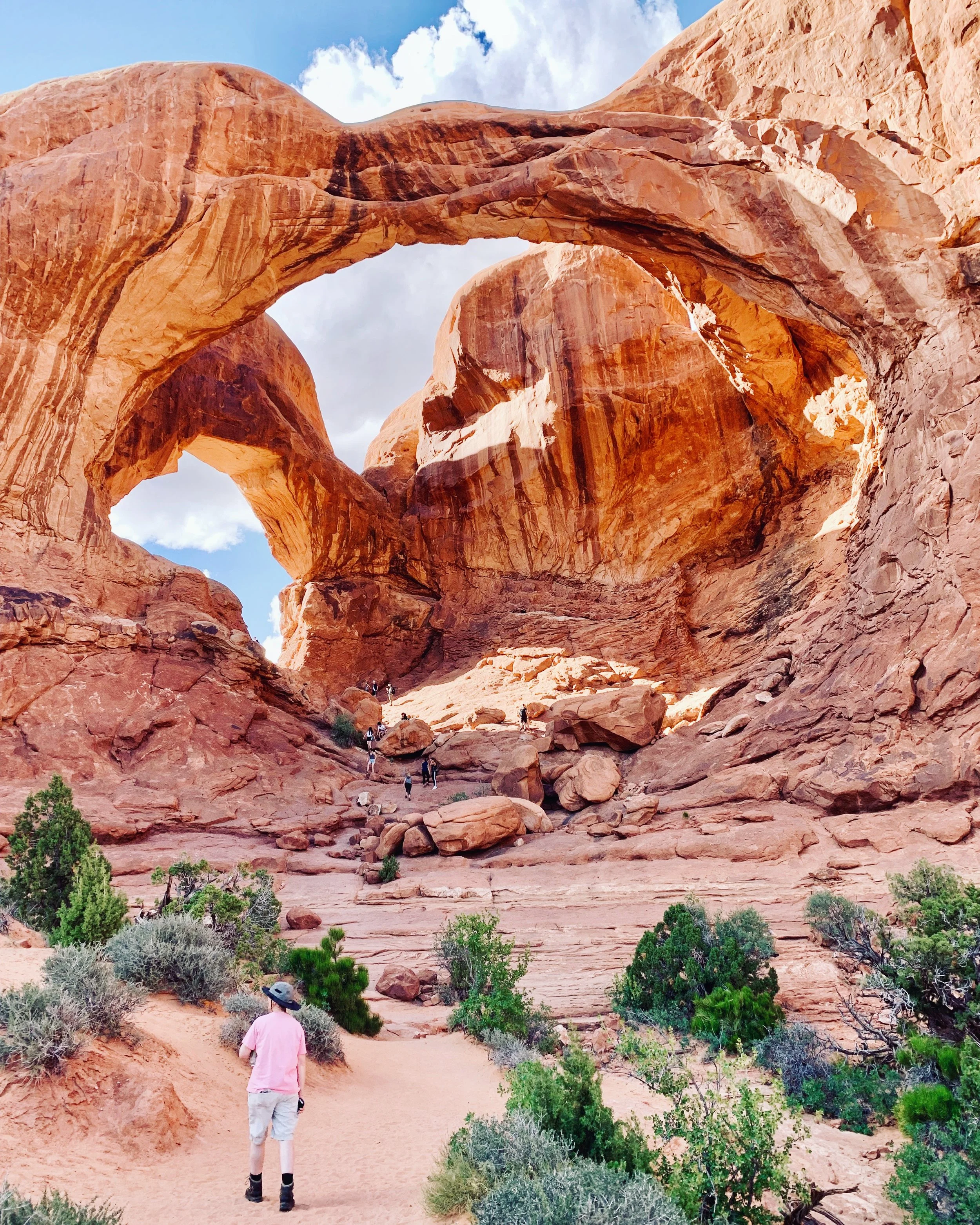
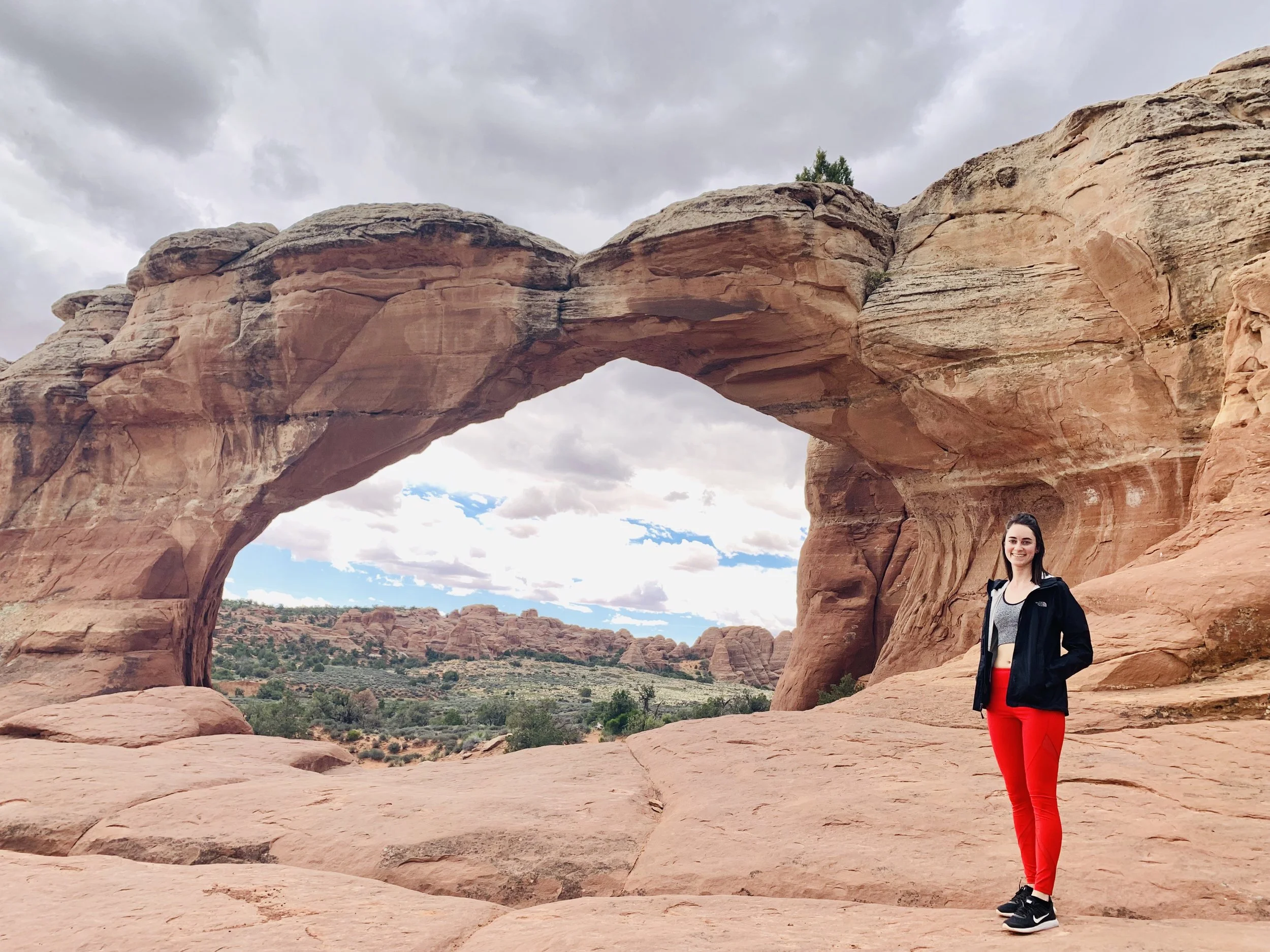
Having scouted Arches the previous day, we came back in the morning with a plan. We set out to see the most popular arch, Delicate Arch, first. After finding the parking lot for the hike overflowing with cars and humans, we decided to just walk to the Delicate Arch overlooks instead, where you can see the arch from afar. Though it seems like the hike and arch itself are most likely always crowded, it’d be awesome to get up close if you have more time! We prioritized the Sand Dune Arch and Broken Arch combined hike instead. This trail is located in the Devil’s Garden area of the park and is one of the last points on the drive. The Sand Dune Arch hike is a quick .3 miles and gets you between some sandstone “fin” structures which feels like you’re in a tight canyon. Afterwards, you can continue along the trail to Broken Arch, which isn’t actually broken 🤷♀️. This arch and surrounding landscape are absolutely gorgeous, and instead of being surrounded by dozens of humans trying to take photos, we only saw a handful of others at the arch at the same time we were there.
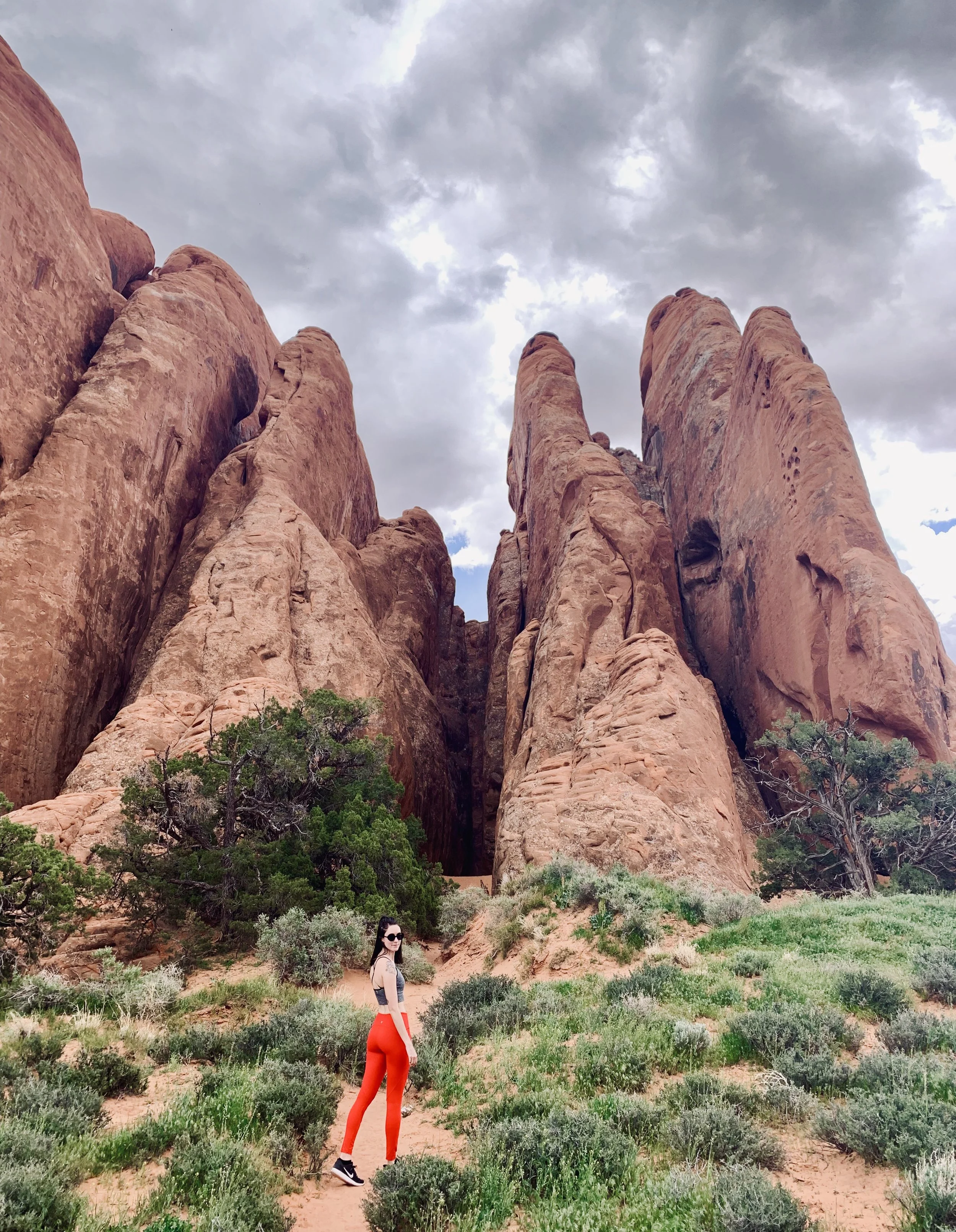
Sandstone fins along the trail to Sand Dune Arch, Arches
🔥Hot Tip: We’ve been told by many that the Fiery Furnace hike is Arches’ best. It’s a natural maze of narrow passages, and some visitors return year after year just to try and make it further towards the end. Sharing of tips among hikers is even highly discouraged to try to keep the mystery alive. You have to book a ranger-guided hike through the Fiery Furnace, or purchase a permit (which can only be done at the Arches visitor center!) in advance for a specific date. Thus, we weren’t able to do the hike in our short timeframe but if you can get a permit or guided tour, this experience comes highly recommended. More info here.
We made it back to Suby (our Subaru) just as it began thundering, lighting, and pouring rain after the Broken Arch hike, and began the drive out to Capitol Reef.
Capitol Reef National Park felt like a hidden gem within the “big 5” Utah national parks, and ended up being our favorite! We’ve been told that Capitol Reef was the last to get paved roads back in the day, and due to the lasting effects of fewer visitors writing about it, it still flies under the radar compared to Arches, Canyonlands, Bryce Canyon and Zion. Right away we were stunned by the high canyon walls, colorful panoramas, hoodoos and arch formations, and the oasis-like valley and historic town of Fruita below.
Our first view of Capitol Reef driving up.
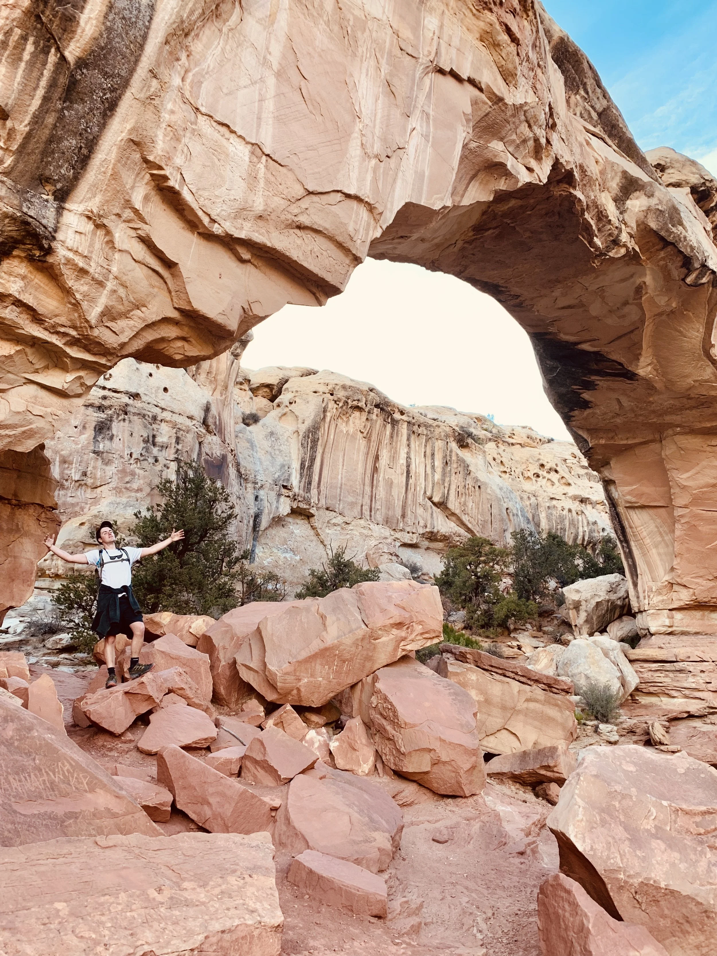
The sole campground in Fruita gets booked months in advance, so we ended up having to get a motel just outside the park for the night. This freed us up to do the Hickman Bridge hike at golden hour, with almost no one else on the trail — which we felt so lucky for!

View from the top of the Hickman Bridge hike, Capitol Reef
⚙️Gear Recommendations:
Day 4: Capitol Reef National Park (pt. 2) and Bryce Canyon National Park (pt. 1)
Sticking to our pattern of exploring our current location in the AM before driving to our next destination, we did the 25-mile scenic drive through Capitol Reef’s major viewpoints and trailheads, stopping along the way to do The “Tanks” hike.
“The Tanks”, Capitol Reef
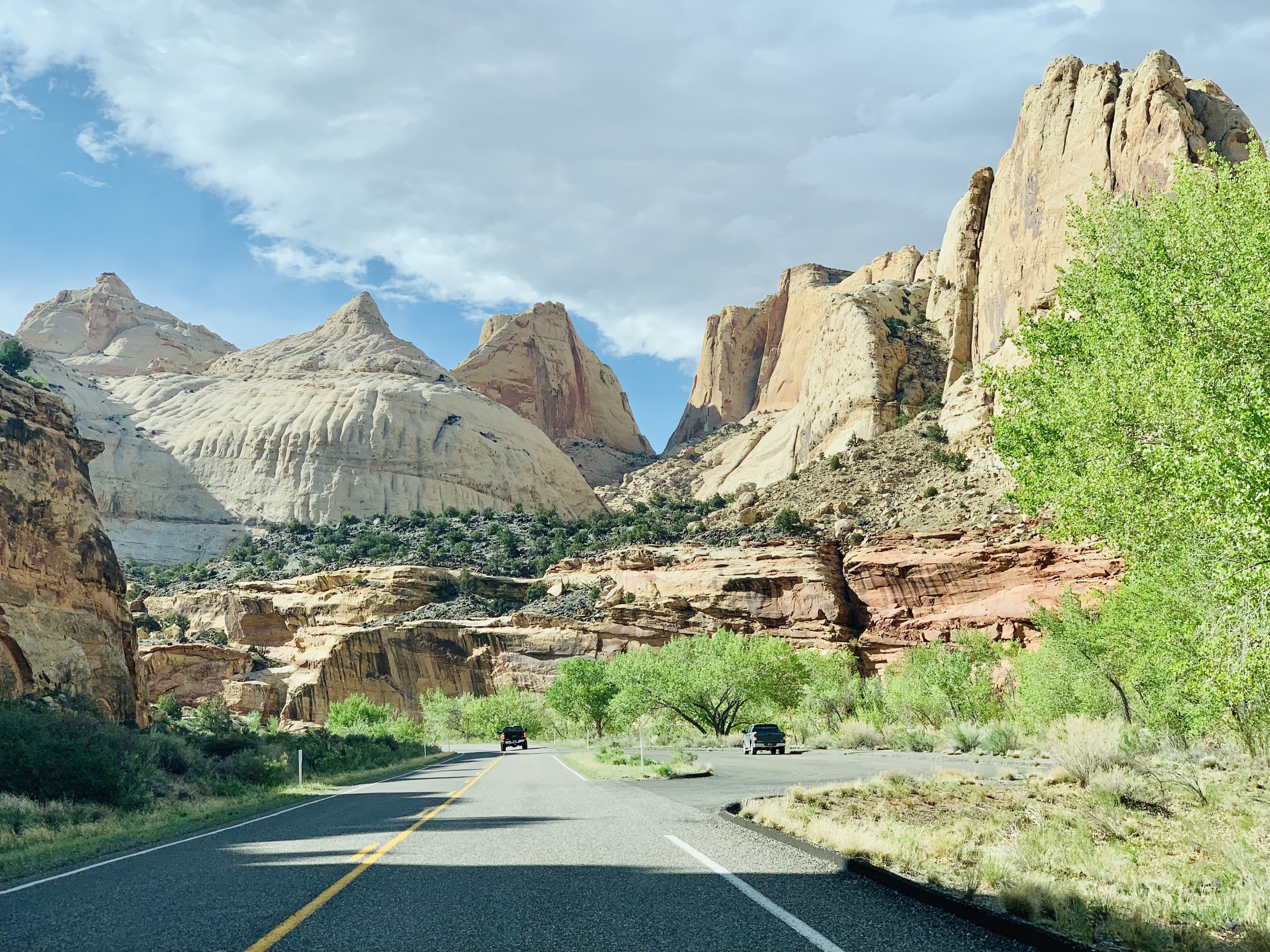
Then it was time for the drive over to Bryce Canyon. It rained the majority of the way across mountain passes to get there, a highlight being the crazy drive through the Grand Staircase - Escalante National Monument, in which you take a winding highway stretch with steep canyon drop offs on both sides.

The Grand Staircase - Escalante
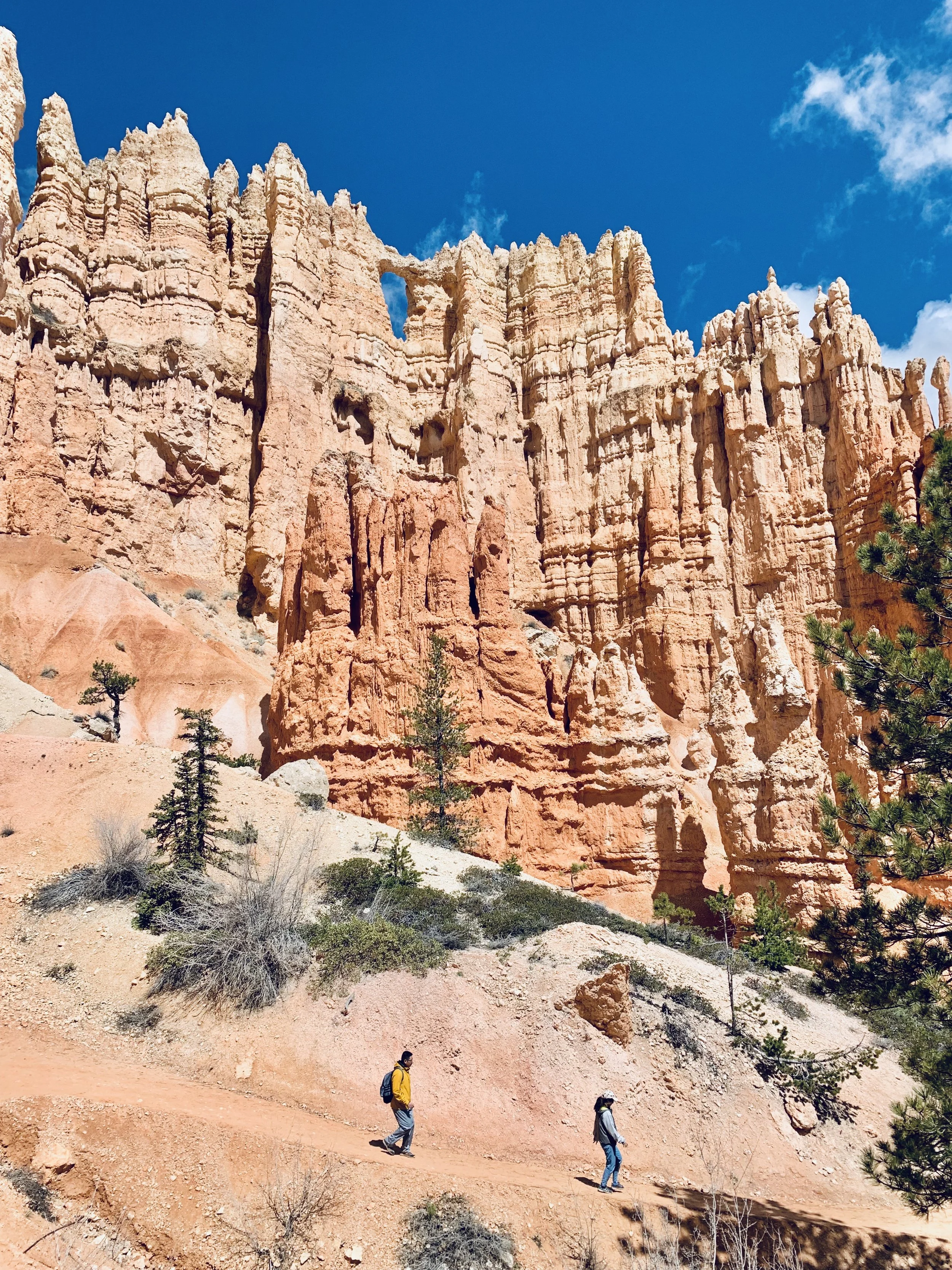
Upon arriving at Bryce, we quickly found that some of the campgrounds were still closed for winter, and the main one was already full. Knowing we’d have to book a hotel back in town, we took the opportunity to hike the rim of Bryce Amphitheater from Inspiration Point to Bryce Point.
We were in absolute awe! We’ve never seen anything like the hundreds of hoodoos lining the amphitheater basin. We literally couldn’t stop taking photos, and had a tough time narrowing them down later on because the view is just so striking and unique.

Hoodoos for dayz, Bryce Canyon
After our hike, we booked a room at the Best Western back in town, grabbed dinner, and planned out a hike for the following day.
Day 5: Bryce Canyon (pt. 2) and Page, Arizona (pt. 1)
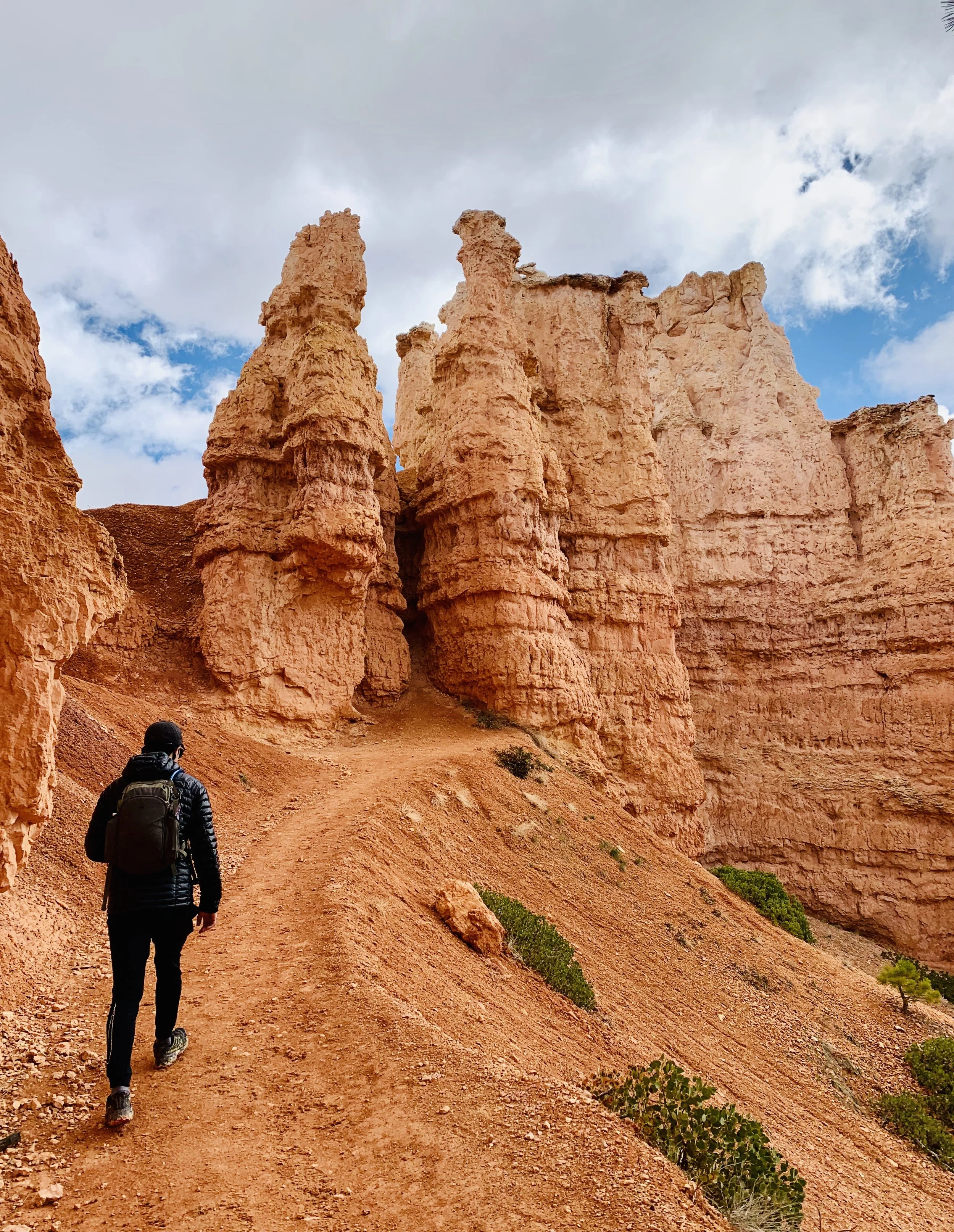
In the morning, we embarked on the 5.1 mile Peekaboo Loop trail, which ventures from Bryce Point quickly to the bottom of the basin, and then follows a loop through some of the basin’s most stunning geological structures and views. The initial switchbacks down into the canyon were still super muddy from recent rain and snow, making the descent a bit interesting, but overall we thought this was a perfect, moderately-difficult hike that gave us up close and personal access to Bryce Canyon’s otherworldly features.
Along the Peekaboo Loop Trail, Bryce Canyon
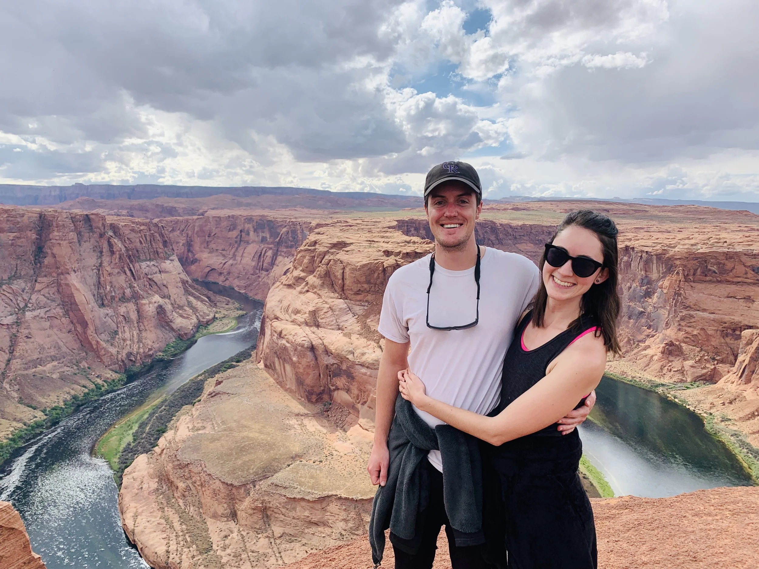
Nice and tired out after the hike, we set out on the drive to Page, Arizona — home to the ever-popular Horseshoe Bend and Antelope Canyon. Sam was pumped to be heading back into warmer weather. We stopped at a nice scenic overlook of Lake Powell on our way into town, then checked in at our hotel and made the short drive over to Horseshoe Bend.
One of the most Insta-famous photography locations in the area, Horseshoe Bend draws crazy crowds of tour busses year-round. So much so that they’re extending the parking area, and also have a shuttle service for when the lots overflow. We felt like part of a pilgrimage along with dozens of other people from around the world on the walk from the parking lot down to the bend.
With sights that touristy, we often wonder if it’s going to be worth it...and for us, Horseshoe Bend was! Even though hundreds of people are there at a time, you have access to walk right up to the edge of the canyon wall around the entire bend. At the time we were there (late spring, weekday, midday), there was plenty of room to go off by yourself and snap good photos. Even the most popular photo spots didn’t have long lines, but we know this isn’t the case at more trafficked times of day, like at sunset, and busier times of year. We were shocked that you can go right up to the edge though, and felt like we witnessed tons of near-death, “do it for the ‘gram” moments happening all around us.
After the bend, we cleaned up back at our hotel, feasted on huge plates of Mexican food in town, and grabbed drinks at the hotel bar to end the night.
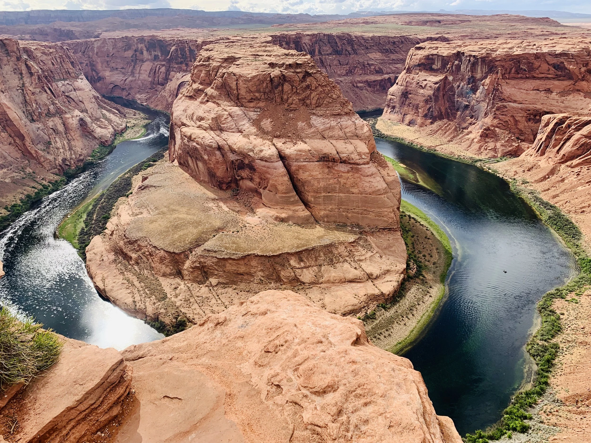
Horseshoe Bend
Day 6: Page, Arizona (pt. 2)
About a week beforehand, we booked a tour of Lower Antelope Canyon with Ken’s Tours. There was only one tour time left at that point, so we definitely recommend booking further in advance. Upper and Lower Antelope Canyon tours are run by totally separate companies, so if you’re interested in doing both you have to book separately. The main difference is that at certain times of day, Upper Antelope Canyon is known for the rays of light that stream into the canyon.
Similar to Horseshoe Bend, you’ll be sharing your Antelope Canyon experience with about 50-60 other tourists. However, they do a good job separating out the groups, and you have plenty of freedom to stop and take photos as you walk the length of the canyon — though you’ll be holding up the people behind you when you do. The tours are led by young Navajo dudes who give tons of interesting info about Navajo and canyon history, and also have the best tips for phone photography within the canyon’s unique angles and lighting. If you’re in the area, Antelope Canyon is a must!

Lower Antelope Canyon
⚙️Gear Recommendations:
We ate lunch at the surprisingly-hip BirdHouse in Page then drove down to the Lees Ferry area to do the Spencer Trail, a 2-mile but 1,600 feet of elevation gain strenuous switchback hike up to the top of a plateau overlooking the Colorado River, Vermillion Cliffs, and Marble Gorge. We hate not finishing things, but this hike just kept going upwards past so many false summits that we actually quit 80% of the way up...oops. Still got the beautiful views though!
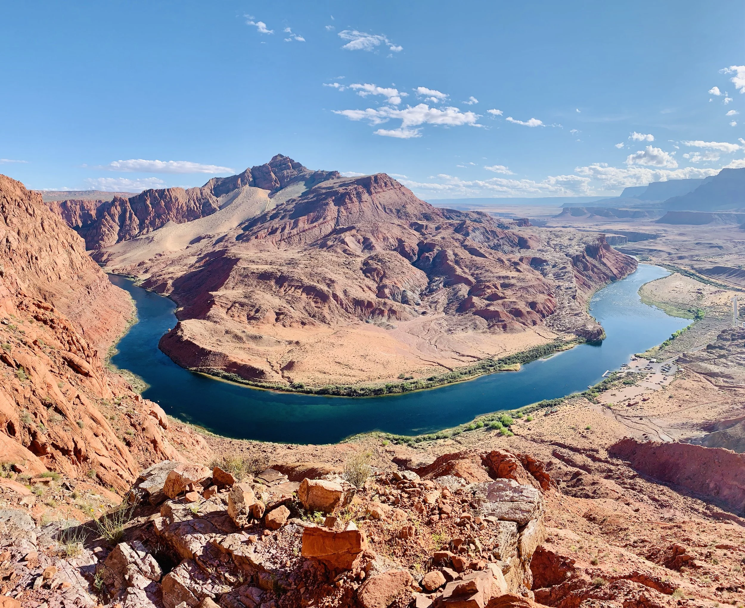
View from the not top of Spencer’s Trail. Still not too shabby, eh?
Afterwards, we cleaned up and got Mexican food again...at this rate we’re ready to compare and contrast all the Mexican restaurants in Page.
Day 7: Driving to Canyon de Chelly, AZ (with a stop at Monument Valley)
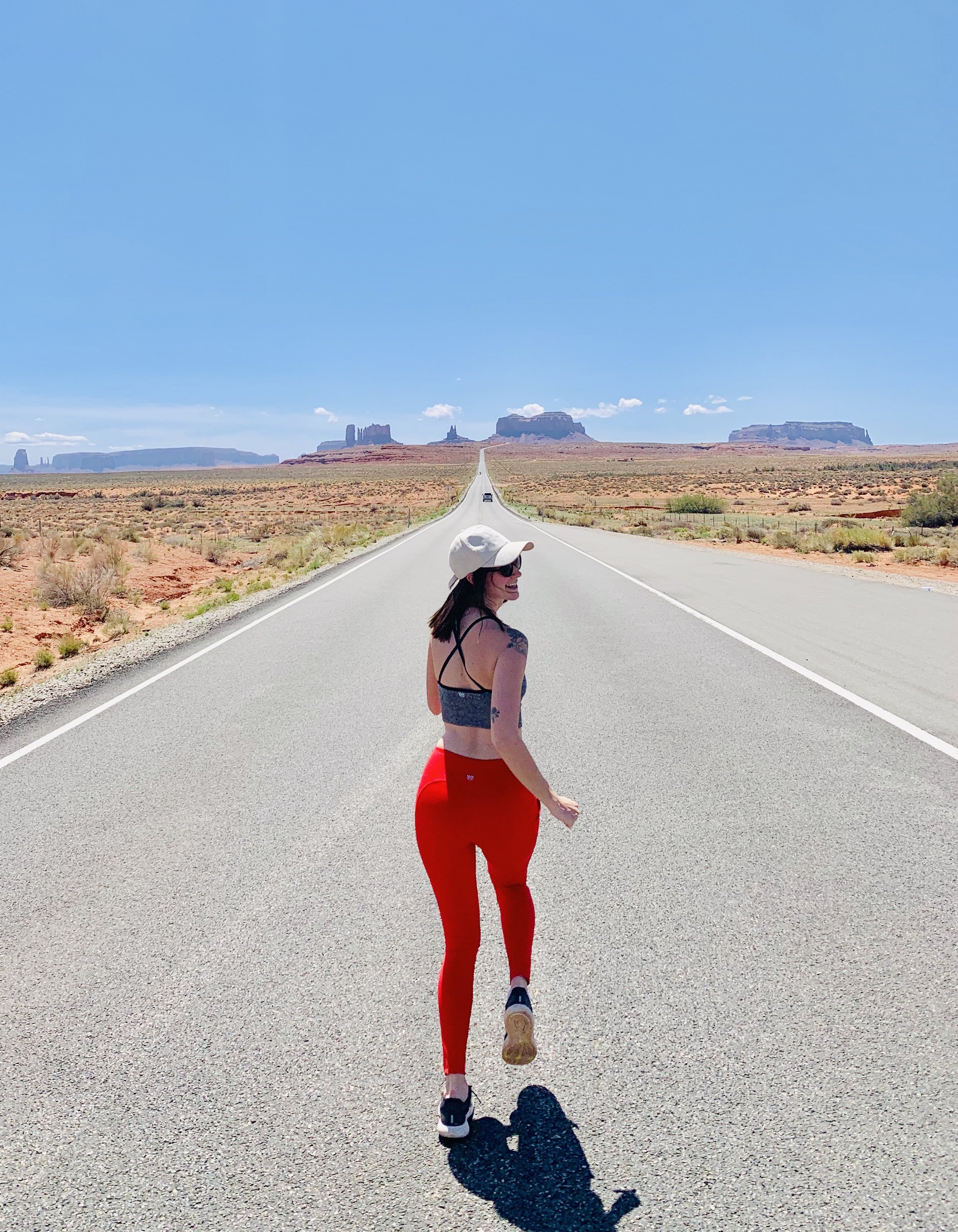
We departed Page around 8:30am to make the drive to Canyon de Chelly, stopping at Monument Valley, AZ along the way. Monument Valley is a Navajo Tribal Park and at the time of writing this it costs $20 per vehicle to enter. As soon as you enter and park at the visitors’ center, you’re greeted by that iconic postcard image of Monument Valley’s three famous structures: East Mitten, West Mitten, and Merrick Butte.
From there, you can take a 17-mile, dirt road loop drive through the park, stopping at many scenic overlooks along the way. You’re not allowed to hike in the park unless you hire a local guide.

Soaking in the scenery at Monument Valley
🔥Hot Tip: For that legendary Forrest Gump / John Wayne highway scene with Monument Valley in the background, you’ll want to exit the park and continue taking highway 163 north for a bit towards Mexican Hat. This was out of the way for us, but would be on your route if you’re heading up north to Moab. Sam kept looking backwards to figure out when we had the perfect view...but you’ll definitely know the spot by the hordes of tourists sitting in the middle of the highway risking their lives to get the perfect shot. Of course we did this too.
🔥Hot Tip 2: We had booked a sunset tour of Canyon de Chelly, but ended up getting confused by Navajo Nation time coming from Page, AZ to Monument Valley, UT and then into Navajo Nation, AZ and missed check-in by nearly an hour! Arizona doesn’t observe Daylight Savings. Navajo Nation lands within Arizona do. So, at the time of year we visited, the Navajo Nation within Arizona was on Mountain Time while the rest of Arizona was on Pacific. When booking any tours or activities on Navajo Nation lands, make double sure whether the tour company is following Navajo Nation time or Arizona time!
🔥Hot Tip 3: It’s pronounced Canyon D’Shay.
We set up camp, rescheduled our tour for the following morning, and did the Canyon de Chelly south rim drive instead. It actually ended up being better that way because we got to see several of Canyon de Chelly’s beautiful overlooks, including Spider Rock, at golden hour — which was beautiful!

Spider Rock, Canyon de Chelly
Day 8: Canyon de Chelly Tour & Back to Colorado
We showed up on time for our tour this time around! Being the middle of the week at a less popular national monument, the tour was entirely comprised of RV-traveling retirees other than ourselves. We all piled into the back of an open-air truck and began the adventure of driving right down the middle of the canyon through the river and all. Our Navajo guide, Harold, provided tons of cool background on growing up in the canyon himself, the Anasazi, Hopi, and Navajo history in the canyon, and the Anasazi ruins and petroglyphs we saw.
After the tour, it was back on the road to our home state! We stayed in Pagosa Springs, CO for one night to split up the drive, then made it home to Denver.
WHERE TO STAY IN THE UTAH & ARIZONA NATIONAL PARKS
If you’re planning on camping in any of the national parks or recreation areas, we definitely recommend reserving camping spots as far in advance as possible. Our trip was planned a bit last minute, and the way our itinerary was laid out, we always arrived at new spots in the late afternoon and had no chance of snagging walk-in sites, so we ended up camping less than we originally planned, and having to book hotels several times.
See below for the places we stayed, as well as recommendations for other sites we mapped out along the way.
Moab Area
Dewey Bridge Campground
Dewey Bridge Campground Road, Moab, UT 84532 | Website
This was the only place we were able to secure a walk-in spot after arriving Friday evening. It’s further away from Moab, Arches, and Canyonlands than a lot of the campgrounds in the area, but still just a quick and beautiful drive away.
You can compare all the campsites in the Moab area here.
Capitol Reef National Park
The Rim Rock Inn
2523 UT-24, Torrey, UT 84775 | Website
The Fruita Campground is really the only game in town if you want to camp within the main part of Capitol Reef, and the reservable spots get booked months in advance. When we visited, some of the more remote campgrounds (1+ hour away) weren’t open for summer yet, and no spots were available in Fruita. So, change of plans and we found ourselves at the Rim Rock Inn! It may look like a typical roadside motel on the exterior, but we found the Rim Rock hospitable, clean, and surprisingly stylish – with beautiful views! Staying so close to the park allowed us to make the most of our short time in the area.
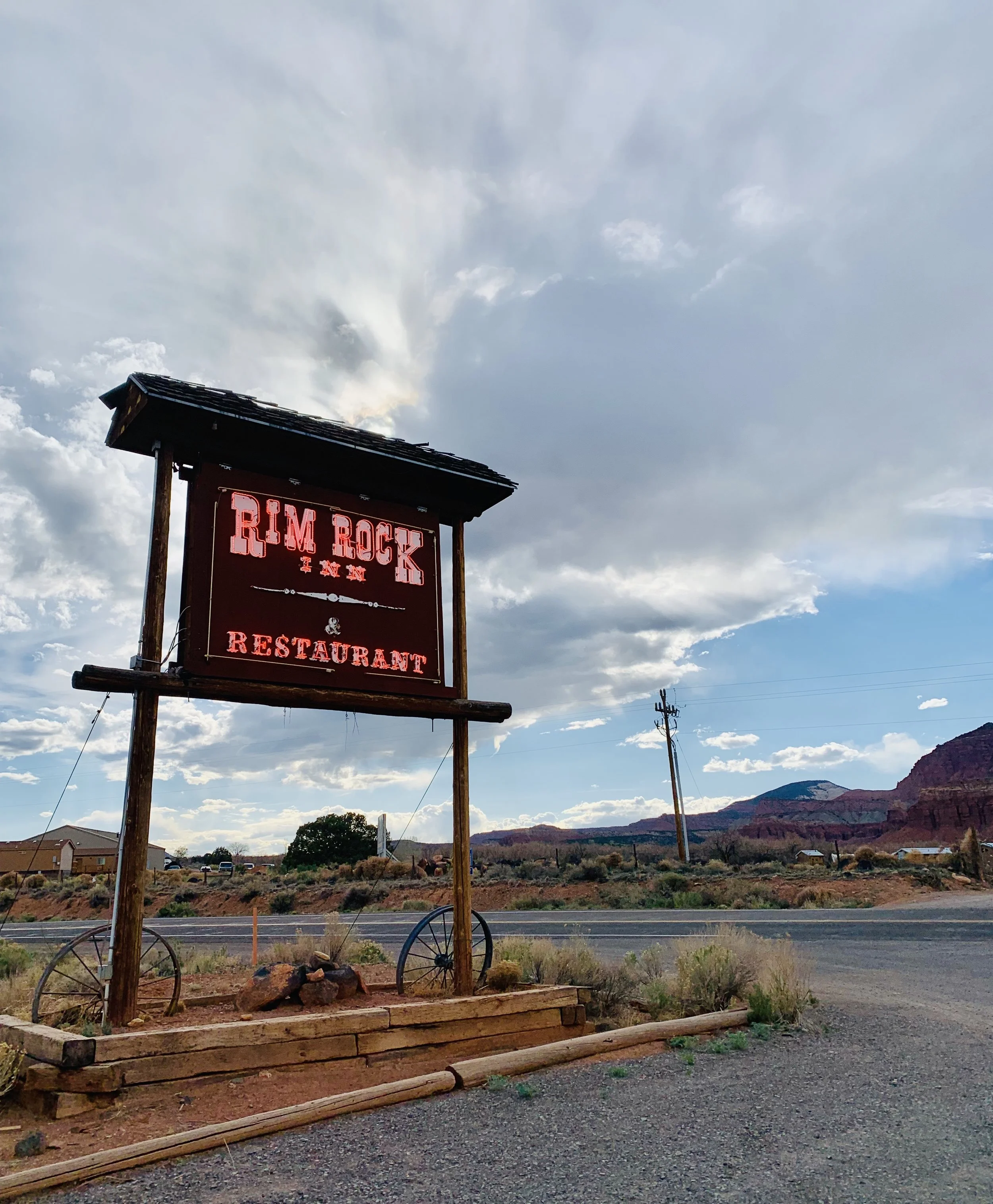
The good ‘ol Rim Rock
Bryce Canyon National Park
Best Western - Ruby’s Inn
26 South Main St, Bryce Canyon City, UT 84764 | Website
Same story, different day. Couldn’t snag a camp site...and honestly it was kinda cold anyway, so Best Western it was! Nothing too special here. If you find yourself in the same situation, there are plenty of hotels in town to choose from.
Page, Arizona
Courtyard Marriott at Lake Powell
600 Clubhouse Dr, Page, AZ 86040 | Website
This place looked more like an old Spanish mission than a Courtyard Marriott – so our aesthetic! Page, AZ is honestly mostly comprised of hotels / motels...so if you find yourself here overnight you’ve got plenty of options to choose from. We happened to have some Marriott rewards points so this little hacienda became our home for two nights. We always love a Courtyard.

Courtyard Marriott or old Spanish mission?
Canyon de Chelly National Monument
Cottonwood Campground
Visitor Center Address: Indn Rte 7, Chinle, AZ 86503 | Camping Info
A nice campground with...wait for it...flush toilets! The campground also has 90 campsites, not to mention that it’s not a super popular area to visit, so it’s easy to walk in and get a spot.

The campground at dusk. Nary another tent-camper like us, mostly RVs.
Pagosa Springs, Colorado
We stayed in Pagosa Springs in southern Colorado for one night to break up the drive back to Denver, and our Airbnb ended up being a room in a huge home on a golf course overlooking the beautiful surrounding peaks. Super relaxing way to end our journey. Use our link for $40 off your first Airbnb stay.
WHAT TO EAT & DRINK IN THE UTAH & ARIZONA NATIONAL PARKS
Capitol Reef National Park
The Rim Rock Patio
2523 UT-24, Torrey, UT 84775 | Website
The Rim Rock Inn has two restaurants, a more upscale one and this casual dining offering that was open late and right up our alley for a good post-hike meal. Their self-description says it best: “A spaghetti western cafe offering an eclectic blend of Italian pizza and Western BBQ with a backdrop Sergio Leone could only dream of.”
Bryce Canyon National Park
Cowboy Ranch House at Bryce Canyon Resort
13500 UT-12, Bryce, UT 84764 | Website
The dining options near the Best Western in Bryce Canyon are sub par at best: the hotel buffet, a grab-and-go fast food place next door with hideous photos of burgers, pizza, and corn dogs on their menu, and a western-themed dinner theater to name a few. We ventured a few miles down the road to Cowboy Ranch and were pleasantly surprised. Ray got chicken tacos he described as “really good and spicy” and Sam even got the Impossible Burger there.
Page, Arizona
El Tapatio
25 S Lake Powell Blvd, Page, AZ 86040 | Website
Pretty sure this is a chain across the southwest (we’ve seen them in CO) but it hits the spot when you’re craving a big ol’ plate of Tex Mex food. The giant menus with huge photos of all the food and drinks was good for a laugh as well. Like most U.S. Mexican restaurant chains, El Tapatio is decorated to the nines with those bright painted chairs and wall decor covering every inch of surface area, which the international tourists couldn’t get enough of.
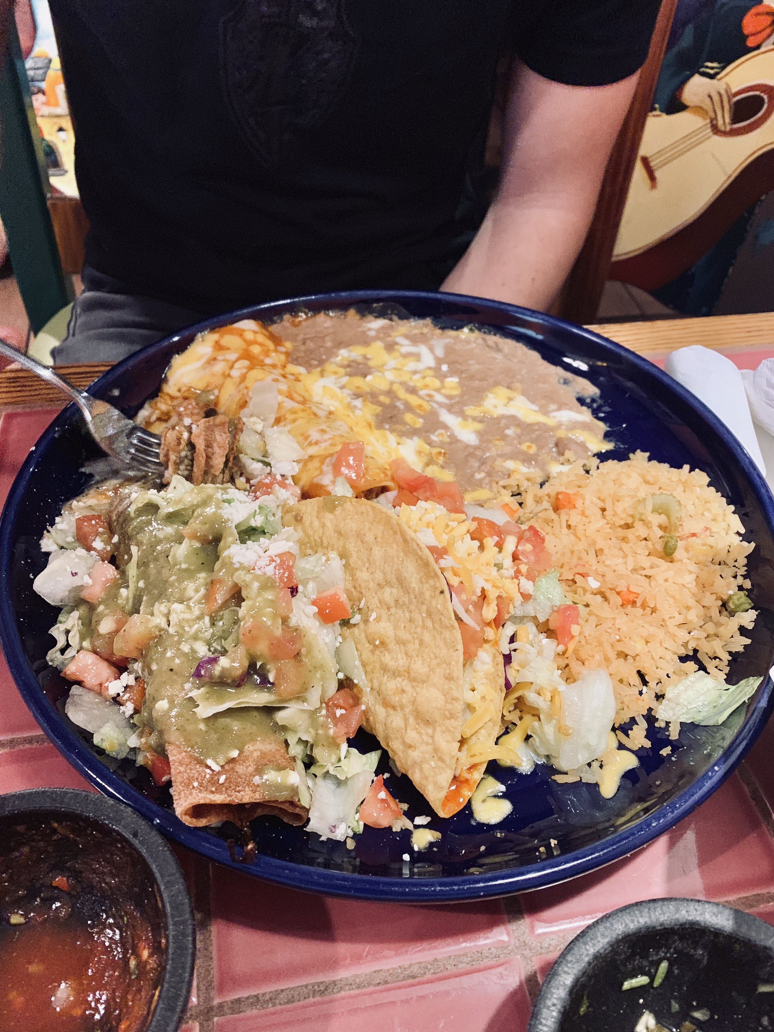
Those portion sizes tho!
Fiesta Mexicana
125 S Lake Powell Blvd, Page, AZ 86040 | Website
El Tapatio and Fiesta Mexicana were the two Mexican restaurants with the most reviews in Page, so naturally we felt the need to rate them against each other. This proved more difficult than expected, however, as they really are quite similar in style and food. We will say Fiesta Mexicana has an outdoor patio that makes for a nice seating ambiance, and they also claim the “best margarita in town” which we tended to agree with.
BirdHouse
707 N Navajo Dr, Page, AZ 86040 | Website
Undoubtedly the trendiest restaurant in Page, in food and drink options, ambiance, everything. Delicious fried chicken boxes, sandwiches, and salads that made for a delicious pre-hike lunch.
WHAT TO DO IN THE UTAH & ARIZONA NATIONAL PARKS
A short recap of all our top sights and experiences mentioned in the itinerary above!
Sand Dune Arch & Broken Arch Hike (Arches)
The only slightly longer hike we did in Arches, a 1.4 mile easy loop. Far less crowded than Delicate Arch! Broken Arch, along with the view from it, are strikingly beautiful! We did get lost while trying to complete the loop, and ended up making this an out and back hike. It’s probably because we were running to avoid the impending thunderstorm, but we found the cairns on the back half of the loop tough to follow!
Broken Arch, Arches
⚙️Gear Recommendations: The North Face black rain jacket
Hickman Bridge Hike (Capitol Reef)
At 2 miles roundtrip, Hickman Bridge is an easy hike and also the most popular in Capitol Reef. We didn’t start until 7pm, however, meaning we got no crowds and beautiful views from the top at golden hour. It’s got gorgeous wildflowers, a trail that passes under the natural bridge (aka arch), and gorgeous views of Fruita and the surrounding monuments from the top.
Ray really feelin’ some typa way at Hickman Bridge.
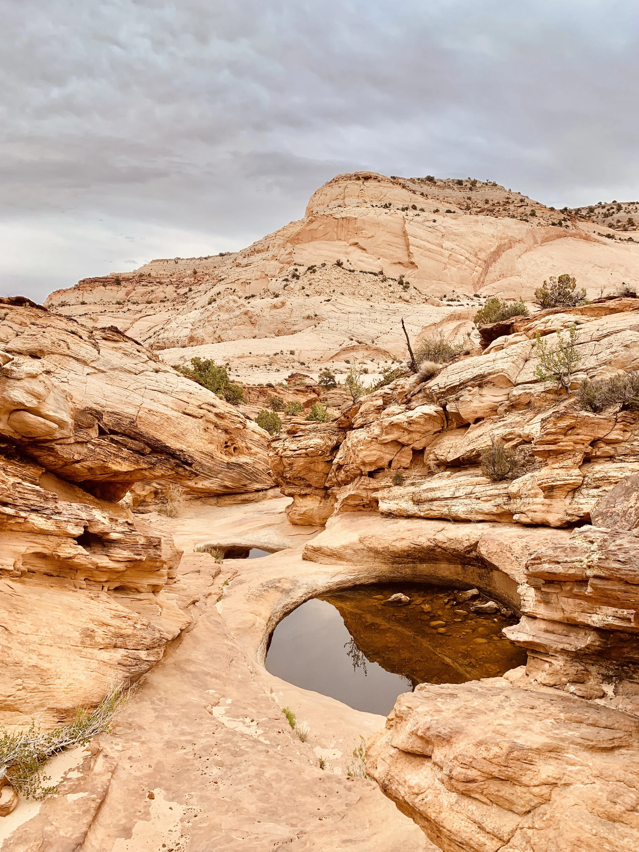
Scenic Drive + Capitol Gorge to Tanks Hike (Capitol Reef)
This 25-mile drive gives you a great overview of Capitol Reef’s most popular sights and trailheads. Along the way, we did the Capitol Gorge hike to the “Tanks” — natural pools of water formed in rock. It’s a 2.4 mile out and back trail that’s extremely easy as it meanders through the canyon, but steep and rock on the side trail to the Tanks.

Atop “The Tanks” hike, Capitol Reef
Inspiration Point to Bryce Point Rim Hike (Bryce Canyon)
A 1.5 mile easy trail between two lookout points on the rim of Bryce Amphitheater. We originally parked at Inspiration Point and couldn’t stop walking along the rim taking photos...until we eventually ended up at Bryce Point. So glad we did the full walk for endless amazing views!

Along the rim trail, Bryce Canyon
Peekaboo Loop Hike (Bryce Canyon)
A 5.1 mile moderately difficult hike from Bryce Point to the bottom of the basin and all up in the hoodoo action. There are several hikes to choose from within the basin, but we felt this one gave us an awesome overview of Bryce Canyon’s crazy unique features.
Along the Peekaboo Loop Trail, Bryce Canyon
Horseshoe Bend (from Page, Arizona)
A must if you’re in the area! $10 entry per vehicle at the time of this post. As mentioned above, Horseshoe Bend will always draw a huge crowd, but at the time we visited it was totally possible to find spots of your own and to get great photos without waiting in a long line.
Horseshoe Bend
Lower Antelope Canyon Tour (from Page, Arizona)
We went on an 11am tour with Ken’s Tours. Another must-do if you’re in the area. Although you’ll be exploring the canyon with dozens of other tourists, there’s nothing like the unique structure of the canyon walls, making for crazy awesome photos.

One of our favorite shots from inside Lower Antelope Canyon
Spencer’s Trail (from Page, Arizona)
What a doozy, especially if it’s hot out! A 2-mile but 1,600 feet of elevation gain strenuous switchback hike up to the top of a plateau overlooking the Colorado River, Vermillion Cliffs, and Marble Gorge.

Muddy boots on Spencer’s Trail
Monument Valley Scenic Drive
On a 17-mile drive through the Navajo Tribal Park, you’ll see some of the most iconic scenery in American Western culture. $20 per vehicle entry. Outside the park and a couple miles up the highway is the popular “Forrest Gump” highway shot with Monument Valley in the background.
“That” shot at Monument Valley
Canyon de Chelly Tour
We booked a 4-hour tour with Thunderbird Lodge, which took us through the bottom of the canyon to view ancient Anasazi cliff dwellings and petroglyphs.
We hope this Utah and Arizona national parks road trip map and guide has been helpful as you plan your own perfect road trip. Questions or U.S. national parks tips of your own? Leave us a comment below or on our latest IG post!
Happy travels!